


.jpeg)


.JPG)


Today I'm entertaining a good friend. I'll show photos soon. So this is a scheduled post.
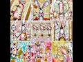
I'll probably NEVER finish this altered book, which I began back in early 2004. But I plan to work on it and put a big dent in the huge number of things I have gathered for it. So, sit back and prepare to be inundated once again with South America and other entries in my 7 Continents AB, what I jokingly call my longest WIP.
Some of you who are long time visitors to my blog might wonder why I have spent so much time in South America in my 7 Continents altered book. It's simple. I have a ton (and I mean a TON) of images, maps, transparencies, encyclopedia entries, and ephemera I can use to create altered book pages for Europe, Asia, North America, and even Antarctica. But I have practically nothing for Africa, Australia, and South America. I guess that's why I'm spending so much time in South America, right now. It's a genuine challenge finding the right images and ephemera.
 I thought I had shown this months and months ago, but when I searched for it, I didn't find this entry. It's not the best entry in the world, but again, I'm just trying to use up these pieces I've accumulated over time.
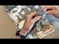
 Yesterday I created this piece. I wasn't sure how well it would scan because of the embellishment I made using fancy fibers. But for the most part, I was happy with what I got.
 Here's a look at why I called this Latitude and Longitude. It shows how South America is broken up between the northern and southern hemispheres and is in the western hemisphere. I also used a rubber stamp to add a slight bit of interest to the color map. I found both of these images in a world geography book (first edition even, although in very, very rough condition) copyrighted 1912.
Thanks for looking and following me on this imaginary journey through the 7 continents.


7 thoughtful remarks:
This seems to be developing into a lifelong piece of art! South America is a very interesting continent, and I can understand your fascination for it, and hope you will find all the ephemera etc that you need. Hugs, Valerie
You found some great maps!
I am always drawn to maps and far away places.
You've used the maps really well here and the orange is a great background to help make everything pop!
The fiber is a nice accent too.
oxo
What a fab continent indeed and your AB pages are fabulous! All this details and photos make them so good!
oxo
Susi
wonderful elements you found for this one. i love graphics and the old Atlas page is wonderful, the newer ones just don´t have These great Colors any more.
one of my best Girl friends is just trekking in peru for 4 weeks and i hope everything goes fine for her. it will be good to see her back, i would not have the Courage to do that. well, actually i´m lacking the Fitness LOL!!
The fibers you chose really complement the map!
This has really sparked my interest, I had no idea that Chile stretched so far along the coast or that it went so far south! Some things I do remember from my geography days at primary school(sadly nothing from secondary school - I only remember the history lessons because the teacher was so good!!) The line map you show on your first page was so easy to see! I love your pages - the colours you have chosen are just right! Hugs, Chrisx
Post a Comment